Overview
In Mongolia the predominant placer gold mining takes place in alluvial sands and gravels of the Neogene and mainly Quaternary periods. Leading areas are the placer areas of Zaamar, Sharyngol, and Yeroo. However, placer gold can be found all over Mongolia and also in Jurassic conglomerates in ancient fluvial terraces.
The Quaternary in Mongolia contains three, possibly four, glacial stages in the Late Pleistocene and the post-glacial stage in the Holocene. The former epoch is characterized by glaciers in a few mountain areas, and the latter by floods of meltwater from melting glaciers and permafrost, and large rivers, which transported and deposited gravels, sand, and gold downstream.
Glacial Stages
At the beginning of the Miocene the climate became arid and cooler and the steppe and grassland appeared. The steppe further expanded in the Messinian in Late Miocene until the Pliocene and Pleistocene. The last ice age began in the Late Pleistocene around 71'000 years ago. Valley glaciers and small ice caps around the peaks in isolated high mountain areas of the Altai, Hangai, Khuvsgul, and Khentii developed.
The climate became warmer at the beginning of the Holocene, and so most glaciers began to melt. Glaciers exist only in the Altai today.
Postglacial Gold
The melting of the glaciers and thawing of the permafrost began with the global warming in the Holocene around 12'000 years ago. The melting caused the lakes and the rivers to swell. The lakes In the Altai, the Selenge and Orkhon Rivers in Hangai, and the the Tuul, Kharea, Yeroo, Khuder, Onon, and Kherlen Rivers in the Khentii mountains. The two million years old Khuvsgul Lake in northern Mongolia was dramatically filled up with meltwater to its actual level during the Holocene, about 5'000 years ago.
During the Pliocene, Pleistocene and Holocene the large Mongolian rivers deposited huge amounts of sediments and gold, such as in the valleys of the Yeroo River in Selenge and of the Tuul River in Zaamar.
Placer Delineation
Rivers are dynamic water bodies that meander and change their courses over time. The channels, where the dense gold (specific gravity of gold is 19.3 when pure) is concentrated, become flooded and deeply buried under younger alluvium. The art of finding the gold placers lies in finding these paleochannels below the surface.
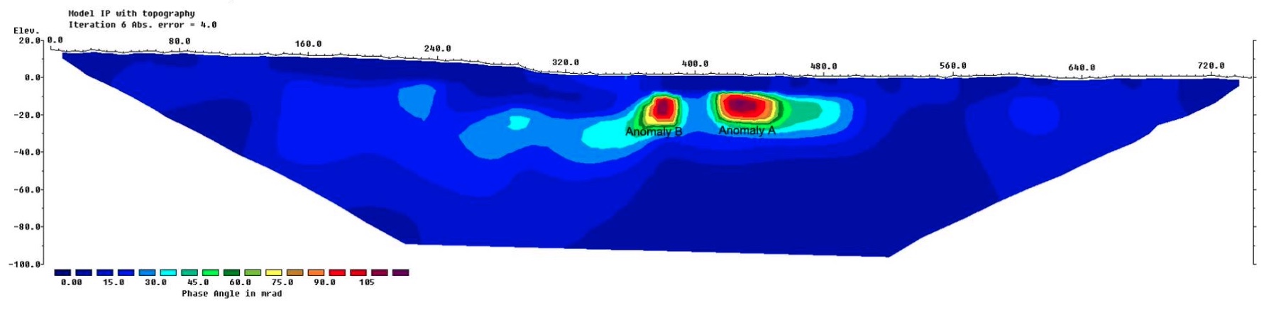
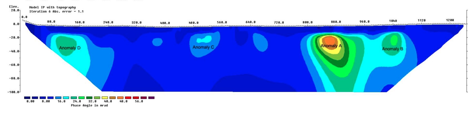
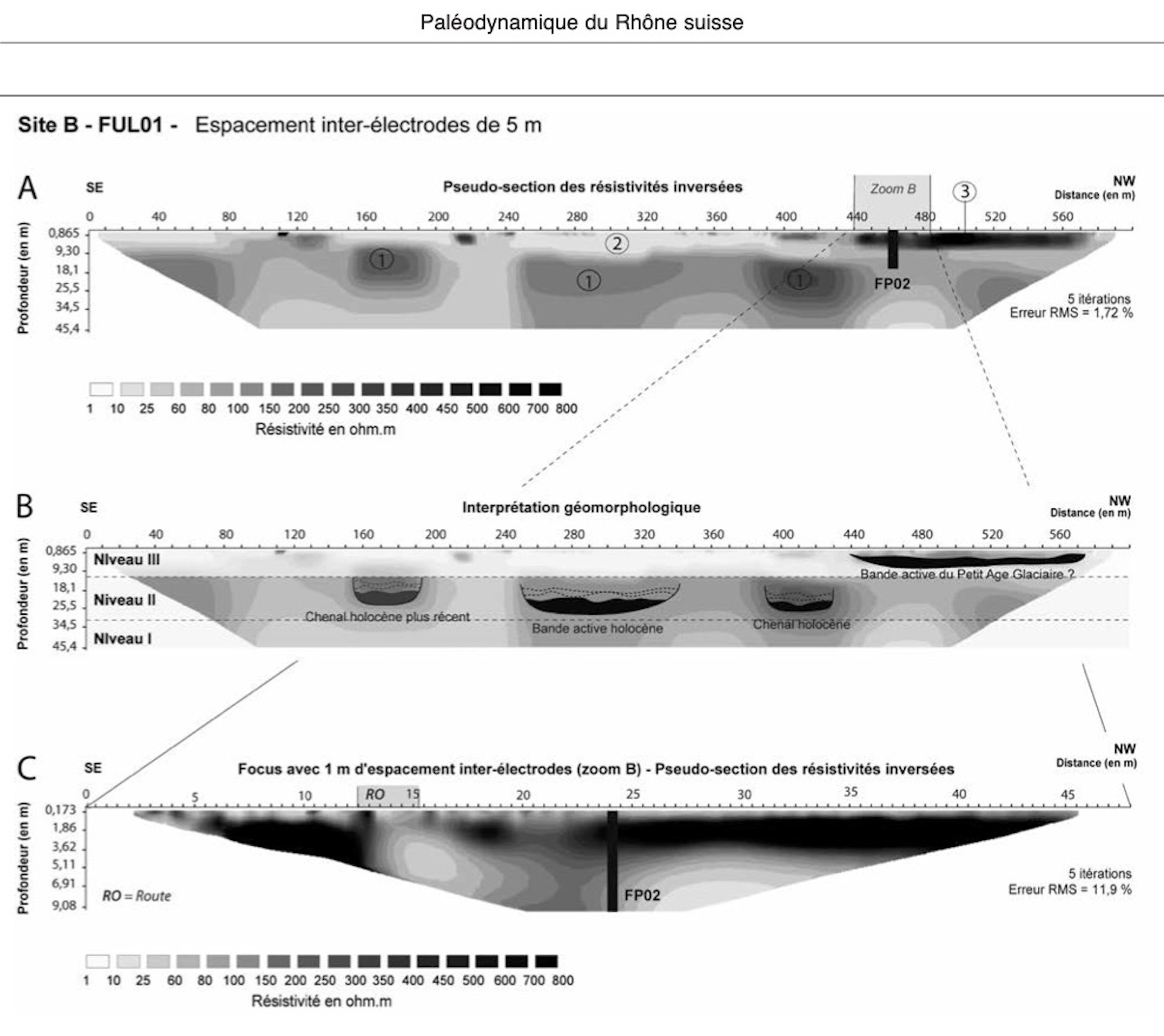
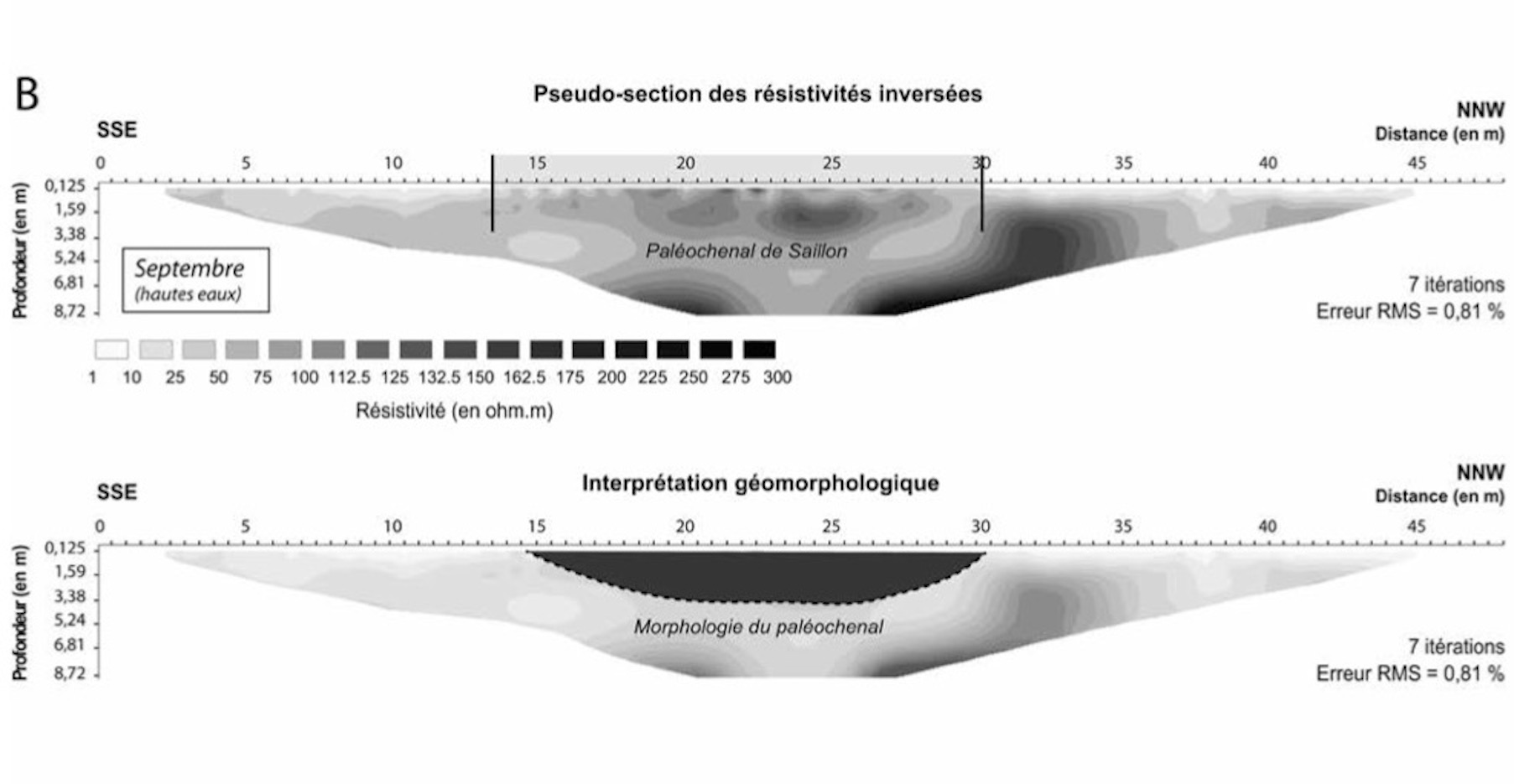
High-resolution Electrical Resistivity Tomography (ERT) and Induced Polarisation (IP) are two proven methods for the visualisation of buried paleochannels with 2-D and 3-D images. The methods are non-invasive and highly mobile. The high-resolution images will also help to optimise the positioning of the bore holes, which are to be drilled 20m or 50m distant from each other.
As shown in the images below the methods were used in the Ladue River of the Yukon placer area in Canada and in the Rhône River in Switzerland. Both are located in post-glacial environments. The images show vertical sections from one side of the valley to the other.
IP - The IP anomalies of the Ladue River indicate placer deposits consisting of IP-active minerals, such as pyrite and magnetite, which are commonly found together with gold.
ERT - The ERT anomalies of the Rhône River indicate ancient stream channels filled with material that is coarser than that of the surrounding flood plains. Stream channels are typically filled with gravel, whereas flood plains consist of fine mud; both have different physical properties relevant to ERT.